
|
Trips, Socials, Events
|
News
|
Banff Film Festival Fundraiser
|
Chapman Bridge Fundraiser
|
Who We Are
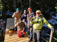
Our members are a group of active outdoor enthusiasts living and playing on the Sunshine Coast of British Columbia, Canada.
The TOC (Tee Oh Cee) is what we call our club, originally known as The Tetrahedron Ski Club, which came into existence in the early 1970's.
Our founding members were mainly employees of Howe Sound Pulp and Paper who first began skiing freshly logged slopes near the mill and later on Mt. Elphinstone and finally in the Tetrahedron Plateau. Through a partnership including the club, local forest industry and the BC Ministry of Forests, four log cabins and a network of trails were built by mostly volunteer labour in 1987, close to 300 volunteers, on land which eventually became Tetrahedron Provincial Park, commonly known as The Tet. Our club continues to maintain these cabins and trails under a stewardship agreement with BC Parks. The generous work of countless volunteers and funds raised through membership, donations and fund raising events, allows the public to enjoy this vast playground, the Tetrahedron Provincial Park.
Our club also supported the Dakota Ridge Winter Recreation Society as they worked and planned to develop our local cross-country, snowshoe and winter recreation site; Dakota Ridge. This site is managed by the SCRD with many of our members volunteering as trail hosts, groomer operators and with the local Jack Rabbits Skills Development Program on the Ridge.
Club Executive
President
Gerry Marcotte
Gerry Marcotte
Directors
|
Reece Armstrong
Marilyn Downey Danny Fleischhacker Michel Frenette |
Ray Hempell
Ryan Matthews Melissa Rayfield |
Bryce Rudland
Leah Thomas Drew Standfield Michael Wilson |
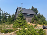
Cabin Stewards
Batchelor Cabin - Gerry and Ellen Marcotte
Edwards Cabin - Jake Stanley
Mt. Steele Cabin - Bryce Rudland and Alex Aegeter
McNair Cabin - Danny Fleischhacker and Melissa Rayfield
Contacts
All executive members, cabin stewards, and the administrator can be reached via email
Officialdom - link to club constitution, policies, procedures. Click here >>
BANFF Centre Mountain Film Festival
The Tetrahedron Outdoor Club proudly presents an annual screening of the Banff Mountain Film Festival as the clubs main fundraiser. Our last event was a sell out on Friday February 3rd, 2023.
This is a major fundraiser for the club to pay for upkeep of cabins, trails and plowing road in winter. The majority of manual work is done by volunteers.
The next BMFF showing will be 1st March 2024. Please get in touch with via email if you would like to sponsor and / or volunteer for this event.
For more information visit our Facebook Event Page here and Instagram Event Page here.
A special THANK YOU to our 2023 BMFF LOCAL SPONSORS
and the volunteers and helpers who help make this community event a great success every year including Elphinstone Secondary School Interact Club members. THANK YOU this would not be possible without you.
|
91.7 Coast FM
Alpha Adventures - Outdoor Adventure Store Behind the Screens Marketing Beyond Consignment Circle Balance Acupuncture and Traditional Chinese Medicine Claytons Coast Reporter Ebs Ice Cream Elphinstone Cycles LTD GM Fitness High Beam Dreams KFrancis cedar Mountain FM 2022 One Tree Wellness |
PaceSetter Athletic Footwear
Real Mushrooms Simon Haiduk Studios Soundwerks Strait Up Climbing Summerhill Fine Homes Sunday Cider Sunshine Coast Community Forest Sunshine Coast Credit Union Sunshine Coast Regional District Tapworks Brewing Co Terra Verde Cleaning Company Trail Bay Source for Sports Trudene and Bill Longman Wellington-Altus Private Wealth |
Sunshine Coast Community Forest
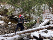
Tetrahedron Outdoor Club Thanks the Sunshine Coast Community Forest for their recent Bridge and Road Maintenance Grants. These major infrastructure grants from the SCCF have allowed us to complete the bridge crossing over Steele Creek and additionally will go towards snow plowing of the Sechelt-Grey FSR.
A Big Thank you SCCF!
A Big Thank you SCCF!